
NHDPlus Pacific Northwest Data (Vector Processing Unit 17)
You may need additional software to view some of the links on this page. See EPA’s Free Viewers and Readers page.The links will vary in file size.
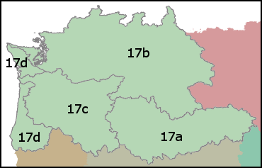
Each major drainage area of the United States contains a suite of NHDPlusV2 data. Within a drainage area, the NHDPlusV2 data components are packaged into compressed files either by Vector Processing Unit (VPU) or Raster Processing Unit (RPU). A drainage area is composed of one or more VPUs and a VPU is composed of one or more RPUs.
| Drainage Area ID | PN |
|---|---|
| VPU | 17 |
| RPUs | 17a, 17b, 17c, 17d |
The following links exit the site
NHDPlusV2 Distribution Filename Key
NHDPlusV2nn_<dd>_<VPUid>_componentname_<vv>
or
NHDPlusV2nn_<dd>_<VPUid>_<RPUid>_componentname_<vv>
where:
- V2nn is Version (2) and subversion (nn) of the NHDPlusV2 data model
- dd is the drainage area identifier
- VPUid is the VPU identifier
- RPUid is the RPU identifier
- Componentname is the name of the NHDPlusV2 component contained in the file
- vv is the data content version, 01, 02, ... for the component
Additional information about the NHDPlusV2 content and distribution format
can be found in the
NHDPlusV2 User Guide (pdf)